![CAD Forum - tips, tricks, discussion and utilities for AutoCAD, Inventor, Revit and other Autodesk products [www.cadforum.cz]](../common/arkance_186.png "CAD Forum - ARKANCE Community - tips, tricks, discussion and utilities for AutoCAD, Inventor, Revit and other Autodesk products [www.cadforum.cz]")
CAD FORUM - TIPS & TRICKS | UTILITIES | DISCUSSION | BLOCKS | SUPPORT | HELP & ASSISTANCE

 What is the ARKANCE Community?
Over 1.124.000 registered users (EN+CZ).
AutoCAD tips, Inventor tips, Revit tips, Civil tips, Fusion tips.
The new Beam calculator, Spirograph generator and Regression curves in the Converters section.
New AutoCAD 2027 commands and sys.variables

 CAD tip # 5525:
Question
A
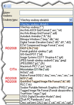
The AutoCAD raster add-on - AutoCAD Raster Design 2008 - extends the list of AutoCAD supported raster files with additional formats, mostly those specialized on satellite mapping.
AutoCAD or Civil 3D with Raster Design supports the following formats of raster image files - Arc/Info ASCII Grid (.asc), Arc/Info Binary Grid (.adf), Autodesk Animator (.flc/.fli), Windows Bitmap (.bmp/.dib/.rle), Digital Terrain Elevation Data (.dt0/.dt1/.dt2), ECW (.ecw), FAST-L7A (.fst), GIF (.gif), GIS-GeoSPOT (.bil), Image Systems CCITT (.ig4), JPEG (.jpg/.jpeg), JPEG2000 (.jp2/.j2k), MacIntosh PICT (.pct/.pict), MrSID (.sid), Native DOQ (.doq/.nes/.ses), NITF (.ntf), QuickBird (.tif/.tiff), RLC (.rlc), Portable Network Graphics (.png), Tagged Image File Format (.tif/.tiff), TrueVision Targa (.tga), USGS Digital Elevation Model (.dem), ZSoft PC Paintbrush (.pcx), CALS Type 1 (.cal/.mil/.rst/.cg4).
CO2008ACAD2008
24.4.2007
17118×
this tip shared by ARKANCE experts applies to: Raster Design 2008 · AutoCAD 2008 ·

CADforum
Tips, tricks, utilities, help, how-tos and FAQ for AutoCAD, LT, Inventor, Revit, Map, Civil 3D, Fusion, Forma, 3ds Max and other Autodesk software (community support by ARKANCE). See About CADforum.
Copyright © 2026 | Advertise with us | Online privacy