

 CAD tip # 12222:

|
| Question | CAD % platform category |
||||||||
|---|---|---|---|---|---|---|---|---|---|
|
|
||||||||
applies to: * · | |||||||||
| See also: | |
| Tip 13971: | What do geolocation codes like 8FWPXFCF+82 or 33UVQ61402434 mean? |
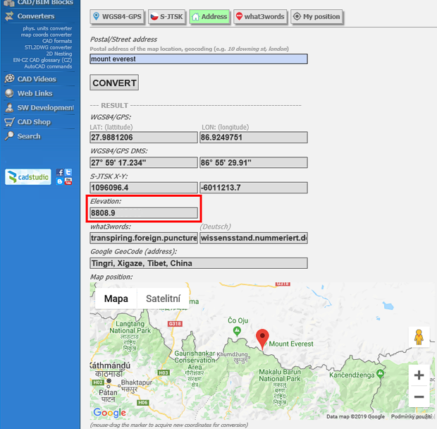
| Tip 12914: | Geo2GPS - GPS or UTM coordinates or web map from any coordinate of an AutoCAD DWG. |
| Tip 11970: | How to find the map coordinate system of a drawing? |
| Tip 10848: | GeoCode with what3words location codes. |
| Tip 9860: | Displaying a DWG including GPS position on a mobile phone or tablet. |
Selected tip:
How to transfer your Plot style table to Excel?
How to set decimal precision (number of dec.places) for Inventor 3D Annotations? « | » After installing the update Inventor 2019.4, the Nesting Utility keeps unloading.
Have we helped you? If you want to support the CAD Forum web service, consider buying one of our CAD applications, or our custom software development offerings, or donating via PayPal (see above).
You may also add a link to your web - like this "fan" link:
|
|
|
Featuring: Add .CIT raster format support to AutoCAD and Map and Civil 3D CITin 
|
Please use these tips at your own risk.
Arkance Systems is not responsible for possible problems that may occur as a result of using any of these tips.
|
Arkance Systems CZ s.r.o. (CAD Studio) - Autodesk Platinum Partner & Training Center & Consulting Services Partner
|
CONTACT:
webmaster.cz@arkance-systems.com tel. +420 910 970 111 |
||
| Copyright © 2024 | Advertise with us | Online privacy |
| ||
