![CAD Forum - tips, tricks, discussion and utilities for AutoCAD, Inventor, Revit and other Autodesk products [www.cadforum.cz]](../common/arkance_186.png "CAD Forum - tips, tricks, discussion and utilities for AutoCAD, Inventor, Revit and other Autodesk products [www.cadforum.cz]")
CAD FORUM - TIPS & TRICKS | UTILITIES | DISCUSSION | BLOCKS | SUPPORT | HELP & ASSISTANCE

Over 1.092.000 registered users (EN+CZ).
AutoCAD tips, Inventor tips, Revit tips.
Try the new precise Engineering calculator.
New AutoCAD 2026 commands and variables.
 CAD tip # 13587:
Question
A
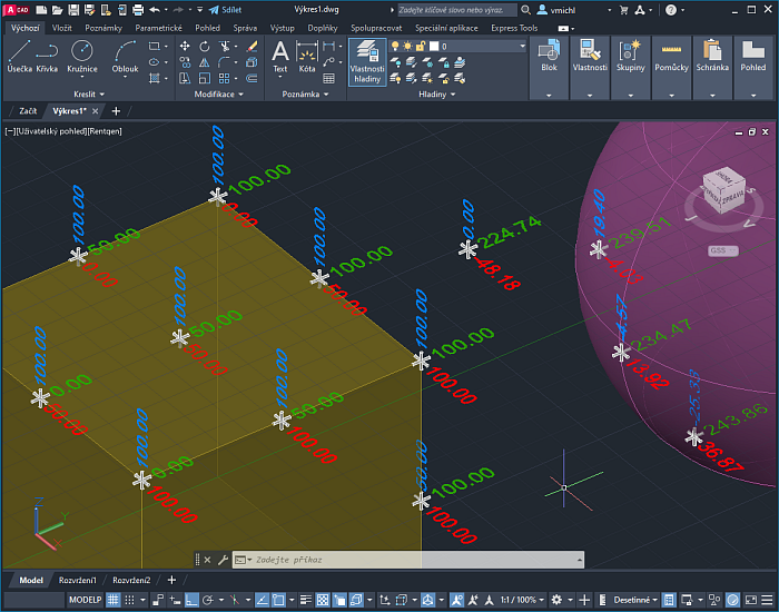
Using automatic text fields referencing the properties of a block reference, you can create a 3D block with a dynamic label of the X/Y/Z coordinate of its insertion point. So you can easily dimension "ordinate" points in 3D - e.g. corner points on your 3D model.
An example of such block can be downloaded from the Block Library - Block 22452: XYZlabel.dwg. When pasted with the appropriate 3D osnap modes, the block will display the values of the individual components of the insertion point coordinate - X, Y and Z (in the planes of that component coordinate).
An example:
ACADACLTCivil3DMapPlant3DADT
30.12.2022
61721×
applies to: AutoCAD · AutoCAD LT · Civil 3D 3D · AutoCAD Map 3D · AutoCAD Plant 3D 3D · AutoCAD Architecture ·


CADforum
Tips, tricks, utilities, help, how-tos and FAQ for AutoCAD, LT, Inventor, Revit, Map, Civil 3D, Fusion, Forma, 3ds Max and other Autodesk software (community support by ARKANCE). See About CADforum.
Copyright © 2025 | Advertise with us | Online privacy