

 CAD tip # 6770:

|
| Question | CAD % platform category |
||||||||
|---|---|---|---|---|---|---|---|---|---|
|
|
||||||||
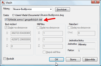
applies to: AutoCAD 2010 · AutoCAD LT 2010 · AutoCAD Architecture 2010 · Civil 3D 2010 · AutoCAD Map 3D 2010 · | |||||||||
") AutoCAD
AutoCAD| See also: | |
| Tip 13971: | What do geolocation codes like 8FWPXFCF+82 or 33UVQ61402434 mean? |
| Tip 13421: | The MAPIINSERT command does not offer a georeference (data from the world file) |
| Tip 13296: | How to correctly load a KML/KMZ file into Civil or Map 3D? |
| Tip 13234: | How to place a GeoTIFF image automatically into the correct position? |
| Tip 11970: | How to find the map coordinate system of a drawing? |
Selected tip:
Assigning CAD commands to a 6-button mouse.
How to convert an AutoCAD Architecture model to 3D solids? « | » How to lower the osnap sensitivity?
Have we helped you? If you want to support the CAD Forum web service, consider buying one of our CAD applications, or our custom software development offerings, or donating via PayPal (see above).
You may also add a link to your web - like this "fan" link:
|
|
|
Featuring: Use Google Earth images in your AutoCAD projects with the Plex.Earth Tools 
|
Please use these tips at your own risk.
Arkance Systems is not responsible for possible problems that may occur as a result of using any of these tips.
|
Arkance Systems CZ s.r.o. (CAD Studio) - Autodesk Platinum Partner & Training Center & Consulting Services Partner
|
CONTACT:
webmaster.cz@arkance-systems.com tel. +420 910 970 111 |
||
| Copyright © 2024 | Advertise with us | Online privacy |
| ||
