AutoCAD Civil 3d Geotechnical module
Printed From: CAD Forum
Category: EN
Forum Name: Civil 3D, Map, InfraWorks
Forum Description: Discussion about mapping and GIS applications Map, Civil3D, InfraWorks, MapGuide and Raster Design
URL: https://www.cadforum.cz/forum_en/forum_posts.asp?TID=13944
Printed Date: 03.Jul.2026 at 03:59
Topic: AutoCAD Civil 3d Geotechnical module
Posted By: MyOtherAvatar
Subject: AutoCAD Civil 3d Geotechnical module
Date Posted: 24.Jan.2024 at 05:43
|
Hello CAD users. I am quite new to the Geotechnical Module. My question here could be silly but please help me out. I tried to create an example boring Location Details but anytime I import the CSV file into CAD, I get an error message attached. My Location Details file has the following columns Location ID, Location Type, Easting, Northing, Ground Level Final Depth (as attached). Can anyone tell me how I can resolve this? Thanks  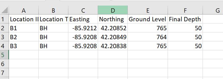 |
Replies:
Posted By: julecave
Date Posted: 27.Aug.2024 at 18:17
| Geotechnical module from Autodesk is the addon you need to use. It can read 2 csv files. 1 for location and another for depths. It can build stratusses and surfaces from it |
Posted By: julecave
Date Posted: 13.Sep.2024 at 02:58
It could be that first row of data. Try removing the header row. It£s a pain esp as you can£t have a csv file with multiple tabs, so I have a bunch of files to process data, format then saved as a csv file https://snaptube.dev/%20" rel="nofollow - - vidmate
|
 julecave wrote: