


 Discussion forum
|

 CAD discussion forum - ask any CAD-related questions here, share your CAD knowledge on AutoCAD, Inventor, Revit and other Autodesk software with your peers from all over the world. To start a new topic, choose an appropriate forum.
Please abide by the rules of this forum.
How to post questions: register or login, go to the specific forum and click the NEW TOPIC button.


AutoCAD Civil 3d Geotechnical module |
Post Reply 
|
| Author | |
MyOtherAvatar 
Newbie 
Joined: 24.Jan.2024 Location: United States Using: AutoCAD2022 Status: Offline Points: 2 |
 Post Options Post Options
") Thanks(0) Thanks(0)
 Quote Reply Quote Reply
 Topic: AutoCAD Civil 3d Geotechnical module Topic: AutoCAD Civil 3d Geotechnical modulePosted: 24.Jan.2024 at 05:43 |
|
Hello CAD users.
I am quite new to the Geotechnical Module. My question here could be silly but please help me out. I tried to create an example boring Location Details but anytime I import the CSV file into CAD, I get an error message attached. My Location Details file has the following columns Location ID, Location Type, Easting, Northing, Ground Level Final Depth (as attached). Can anyone tell me how I can resolve this? Thanks  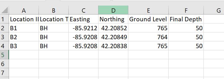 |
|
 |
|
 Topic Options
|
Post Reply
|
|
 Tweet
Tweet
|
| Forum Jump | Forum Permissions You cannot post new topics in this forum You cannot reply to topics in this forum You cannot delete your posts in this forum You cannot edit your posts in this forum You cannot create polls in this forum You cannot vote in polls in this forum |
This page was generated in 0,309 seconds.
|
CAD Forum - tips, tricks, utilities, discussion for AutoCAD, LT, Inventor, Revit, Map, Civil 3D, 3ds Max, Fusion 360 and other Autodesk software (support by Arkance Systems)
|
Arkance Systems CZ (CAD Studio) - Autodesk Platinum Partner & Training Center & Services Partner
|
CONTACT:
webmaster.cz@arkance-systems.com tel. +420 910 970 111 |
|
| Copyright ©2024 | Advertise with us | Online privacy |
| ||
