![CAD Forum - tips, tricks, discussion and utilities for AutoCAD, Inventor, Revit and other Autodesk products [www.cadforum.cz]](../common/arkance_186.png "CAD Forum - ARKANCE Community - tips, tricks, discussion and utilities for AutoCAD, Inventor, Revit and other Autodesk products [www.cadforum.cz]")
CAD FORUM - TIPS & TRICKS | UTILITIES | DISCUSSION | BLOCKS | SUPPORT | HELP & ASSISTANCE

 What is the ARKANCE Community?
Over 1.127.000 registered users (EN+CZ).
AutoCAD tips, Inventor tips, Revit tips, Civil tips, Fusion tips.
The new Beam calculator, Spirograph generator and Regression curves in the Converters section.
New AutoCAD 2027 commands and sys.variables

 CAD tip # 8348:
Question
A
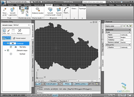
Mapping data in the SHP format (ESRI shape) can be directly read into AutoCAD Map 3D and AutoCAD Civil 3D (any version). See the function (ribbon) Insert tab > Import panel > Map Import.
If your .SHP file contains graphics plus the object (attribute) data, this data will be attached to the imported objects in the DWG and you can use them optionally - display them as text labels or use them for stylization of the imported objects.
See the detailed procedure (Czech version) in the Map video #10
or on the CADstudioCZ channel on YouTube:
MapCivil
1.12.2011
54738×
this tip shared by ARKANCE experts applies to: AutoCAD Map 3D · Civil 3D ·

CADforum
Tips, tricks, utilities, help, how-tos and FAQ for AutoCAD, LT, Inventor, Revit, Map, Civil 3D, Fusion, Forma, 3ds Max and other Autodesk software (community support by ARKANCE). See About CADforum.
Copyright © 2026 | Advertise with us | Online privacy