![CAD Forum - tips, tricks, discussion and utilities for AutoCAD, Inventor, Revit and other Autodesk products [www.cadforum.cz]](../common/arkance_186.png "CAD Forum - ARKANCE Community - tips, tricks, discussion and utilities for AutoCAD, Inventor, Revit and other Autodesk products [www.cadforum.cz]")
CAD FORUM - TIPS & TRICKS | UTILITIES | DISCUSSION | BLOCKS | SUPPORT | HELP & ASSISTANCE

 What is the ARKANCE Community?
Over 1.127.000 registered users (EN+CZ).
AutoCAD tips, Inventor tips, Revit tips, Civil tips, Fusion tips.
The new Beam calculator, Spirograph generator and Regression curves in the Converters section.
New AutoCAD 2027 commands and sys.variables

 CAD tip # 5671:
Question
A
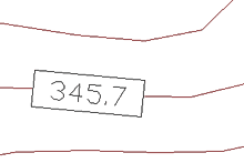
You can label your contour elevations automatically with the help of AutoCAD dynamic blocks functionality (used to its limits). Please find an example of such annotation label in the dynamic block ContourAutoLabel in the CAD block catalog.
If your contours (polylines) are placed in "their" height (Z-coordinate), just use an osnap mode (e.g. NEArest) and insert the block ContourAutoLabel on the contour polyline. The label will be automatically aligned to the direction of the contour, its Height attribute will be set to the Z-coordinate of the insertion point, the value of the coordinate (rounded to one decimal place) will be centered and background will be masked around the label text.
To suppress the frame use the TFRAMES command. To disable the shaded background use the FIELDDISPLAY variable (the background is not printed anyway).
ACAD2009ACAD2008ACAD2007ACLT2009ACLT2008ACLT2007
25.7.2007
36530×
this tip shared by ARKANCE experts applies to: AutoCAD 2009 · AutoCAD 2008 · AutoCAD 2007 · AutoCAD LT 2009 · AutoCAD LT 2008 · AutoCAD LT 2007 ·

CADforum
Tips, tricks, utilities, help, how-tos and FAQ for AutoCAD, LT, Inventor, Revit, Map, Civil 3D, Fusion, Forma, 3ds Max and other Autodesk software (community support by ARKANCE). See About CADforum.
Copyright © 2026 | Advertise with us | Online privacy