Over 1.113.000 registered users (EN+CZ).
AutoCAD tips, Inventor tips, Revit tips, Civil tips, Fusion tips.
The new Beam calculator, Spirograph generator and Regression curves in the Converters section.
 CAD tip # 6048:
Question
A
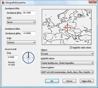
Many Autodesk applications can use the information about the geographical location of your project - either for the calculation of the position of the Sun as a light source for rendering, or for energy calculations of your building (gbXML).
When specifying the location of your project you can use a list of names and geographic coordinates of the most important world cities. If you want to add your own home city or village to this list, you can do so - extend the list of "important" places.
Autodesk applications use the list of cities stored in the file SITENAME.TXT. This file can be found in AutoCAD (and applications based on AutoCAD), in Revit and in the visualization programs Autodesk VIZ and 3ds Max.
You can find the SiteName.txt file in folders like:
C:\Users\username\AppData\Roaming\Autodesk\AutoCAD 2009\R17.2\enu\Support
C:\Documents and Settings\username\Local Settings\Application Data\Autodesk\AutoCAD 2008\R17.1\enu\Support
C:\Documents and Settings\username\Local Settings\Application Data\Autodesk\ADT 2005\enu\VIZRender\PLugCFG
\3dsmax7\plugcfg
C:\Program Files\Revit Architecture 2008\Program
or similar. As an exception, the rendering function in older versions of Revit (Accurender) uses a similar file in:
C:\Program Files\Revit Architecture 2008\Program\Ar3Redist\UnicodeENU\ar_city.uni
Open your SiteName.txt file in the Notepad.exe editor and add a new line to the list of cities (example):
+48.9754 +14.4761 +Ceske Budejovice, Czech Republicwhere the first two values are the latitude/longitude values for the specific site in decimal notation. These values can be easily found using a GPS unit or from online mapping web sites like maps.google.com.
After you save the changed file Sitename.txt, do not forget to restart your CAD application.


ACADADTCivilRevitVIZMax
27.3.2008
11827×
![CAD Forum - tips, tricks, discussion and utilities for AutoCAD, Inventor, Revit and other Autodesk products [www.cadforum.cz] CAD Forum - tips, tricks, discussion and utilities for AutoCAD, Inventor, Revit and other Autodesk products [www.cadforum.cz]](../common/arkance_186.png)


