Over 1.092.000 registered users (EN+CZ).
AutoCAD tips, Inventor tips, Revit tips.
Try the new precise Engineering calculator.
New AutoCAD 2026 commands and variables.
 CAD tip # 5063:
Question
A
AutoCAD Map 3D 2007 (and higher) directly supports online web data using the OGC standard WMS (or WFS). WMS data services can be used on your company network or you can link to public map providers like NASA.
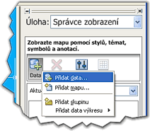
From the Map "Task pane" palette choose "Display manager", click the Data button and select "Add data" from the context menu.

In the Data link palette, click on the WMS item and name your data connection. In the field "Server name or URL" enter the web address of the WMS service and its login credentials. From the downloaded layer (feature) names select the requested layers and click on the "Add to map" button.
To test the WMS functionality you can use e.g. the NASA WMS service.
Map2008Map2007Civil2008Civil2007
12.6.2006
16058×
![CAD Forum - tips, tricks, discussion and utilities for AutoCAD, Inventor, Revit and other Autodesk products [www.cadforum.cz] CAD Forum - tips, tricks, discussion and utilities for AutoCAD, Inventor, Revit and other Autodesk products [www.cadforum.cz]](../common/arkance_186.png)


