![CAD Forum - tips, tricks, discussion and utilities for AutoCAD, Inventor, Revit and other Autodesk products [www.cadforum.cz]](../common/arkance_186.png "CAD Forum - ARKANCE Community - tips, tricks, discussion and utilities for AutoCAD, Inventor, Revit and other Autodesk products [www.cadforum.cz]")
CAD FORUM - TIPS & TRICKS | UTILITIES | DISCUSSION | BLOCKS | SUPPORT | HELP & ASSISTANCE

 What is the ARKANCE Community?
Over 1.124.000 registered users (EN+CZ).
AutoCAD tips, Inventor tips, Revit tips, Civil tips, Fusion tips.
The new Beam calculator, Spirograph generator and Regression curves in the Converters section.
New AutoCAD 2027 commands and sys.variables

 CAD tip # 9255:
Question
A
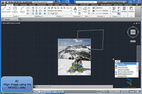
When fitting maps, inserting logos and other operations, you may need to align an image (its size, position, rotation) to an existing geometry in an AutoCAD drawing. In special cases you will also need to independently (separately) adjust the image width and height (the aspect ratio of its pixels).
Three different methods of alignment and fitting images are illustrated in the video-tip "Aligning images", available in the section "CAD Video" - see:
or on the CAD Studio's YouTube channel:
This video-tip describes:
- The standard AutoCAD command ALIGN, which changes position, size and rotation of an image - but it cannot change its aspect ratio (X/Y pixel size)
- The utility CADstudio ImgAdj (see
 Download), which can independently modify image width and height; load it with APPLOAD and run the IMGADJ command
- The command IRSHEET from AutoCAD Raster Design (included in the version "AutoCAD Design Suite" and in other Autodesk Collections), which performs a general transformation, rubbersheeting - adjusting the shape and contents of a raster image to the target outline.
Other options for adjusting position, size and rotation of images are available through the georeferencing functionality included in mapping versions of AutoCAD (Map 3D, Civil 3D).
ACADADTCivilMap
19.5.2013
44031×
this tip shared by ARKANCE experts applies to: AutoCAD · AutoCAD Architecture · Civil 3D · AutoCAD Map 3D ·

CADforum
Tips, tricks, utilities, help, how-tos and FAQ for AutoCAD, LT, Inventor, Revit, Map, Civil 3D, Fusion, Forma, 3ds Max and other Autodesk software (community support by ARKANCE). See About CADforum.
Copyright © 2026 | Advertise with us | Online privacy