


 CAD tip # 14095:

|
| Question | CAD % platform category |
||||||||
|---|---|---|---|---|---|---|---|---|---|
|
|
||||||||
applies to: AutoCAD · AutoCAD Architecture · AutoCAD Plant 3D · AutoCAD Mechanical · Civil 3D · AutoCAD Map 3D · | |||||||||
") AutoCAD
AutoCAD| See also: | |
| Tip 9238: | Increasing resolution of shaded documentation view in AutoCAD. |
| Tip 6354: | How to save a Mechanical Desktop 3D model to the STL format? |
| Tip 4629: | Arcs imported from AutoCAD/ADT are displayed too roughly in VIZ/max. |
| Tip 810: | Holes are displayed very roughly. |
Selected tip:
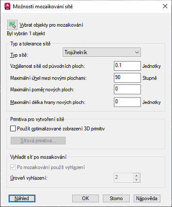
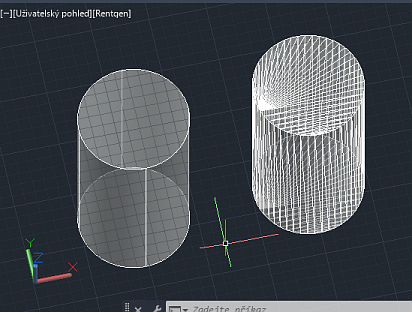
How to show complete two-sided 3D model during 3D Orbit?
How to use arc length parameter in Inventor sketch? « | » 3D terrain model of any place in Czechia - elevation data by the Czech Land Survey Office (CUZK) into Civil 3D.
Have we helped you? If you want to support the CAD Forum web service, consider buying one of our CAD applications, or our custom software development offerings, or donating via PayPal (see above).
You may also add a link to your web - like this "fan" link:
|
|
|
Featuring: Add .CIT raster format support to AutoCAD and Map and Civil 3D CITin 
|
Please use these tips at your own risk.
Arkance Systems is not responsible for possible problems that may occur as a result of using any of these tips.
|
Arkance Systems CZ s.r.o. (CAD Studio) - Autodesk Platinum Partner & Training Center & Consulting Services Partner
|
CONTACT:
webmaster.cz@arkance-systems.com tel. +420 910 970 111 |
||
| Copyright © 2024 | Advertise with us | Online privacy |
| ||
