![CAD Forum - tips, tricks, discussion and utilities for AutoCAD, Inventor, Revit and other Autodesk products [www.cadforum.cz]](../common/arkance_186.png "CAD Forum - ARKANCE Community - tips, tricks, discussion and utilities for AutoCAD, Inventor, Revit and other Autodesk products [www.cadforum.cz]")
CAD FORUM - TIPS & TRICKS | UTILITIES | DISCUSSION | BLOCKS | SUPPORT | HELP & ASSISTANCE

 What is the ARKANCE Community?
Over 1.124.000 registered users (EN+CZ).
AutoCAD tips, Inventor tips, Revit tips, Civil tips, Fusion tips.
The new Beam calculator, Spirograph generator and Regression curves in the Converters section.
New AutoCAD 2027 commands and sys.variables

 CAD tip # 9860:
Question
A
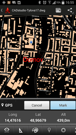
With the mobile version of AutoCAD - AutoCAD 360 you can use your smartphone or tablet to display your current GPS position in a DWG drawing of a city map, construction or utility site. And the DWG contents can be automatically synchronized with your "desktop" version of AutoCAD or AutoCAD LT. Download.
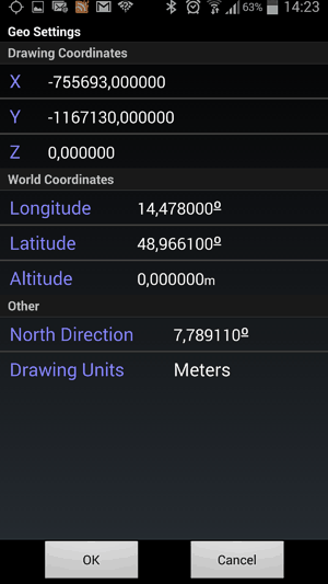
If you have the particular drawing (map) geolocated in a coordinate system in AutoCAD, the GPS coordinates (WGS84) will match automatically, otherwise you can se the location and possible rotation of the drawing also in AutoCAD 360 - see the command (the bottom menu) Location > Settings:
Download.
ACAD360ACADWSMapCivil
5.6.2014
39133×

CADforum
Tips, tricks, utilities, help, how-tos and FAQ for AutoCAD, LT, Inventor, Revit, Map, Civil 3D, Fusion, Forma, 3ds Max and other Autodesk software (community support by ARKANCE). See About CADforum.
Copyright © 2026 | Advertise with us | Online privacy