![CAD Forum - tips, tricks, discussion and utilities for AutoCAD, Inventor, Revit and other Autodesk products [www.cadforum.cz]](../common/arkance_186.png "CAD Forum - ARKANCE Community - tips, tricks, discussion and utilities for AutoCAD, Inventor, Revit and other Autodesk products [www.cadforum.cz]")
CAD FORUM - TIPS & TRICKS | UTILITIES | DISCUSSION | BLOCKS | SUPPORT | HELP & ASSISTANCE

 What is the ARKANCE Community?
Over 1.127.000 registered users (EN+CZ).
AutoCAD tips, Inventor tips, Revit tips, Civil tips, Fusion tips.
The new Beam calculator, Spirograph generator and Regression curves in the Converters section.
New AutoCAD 2027 commands and sys.variables

 CAD tip # 8679:
Question
A
The automatic schedule (table) of the drawing objects properties created with the DATAEXTRACTION command can be updated manually or automatically on a change in the drawing.
For manual updates use the command DATALINKUPDATE. It is available also in the table's context menu (mouse right-click) - "Update Table Data Links".
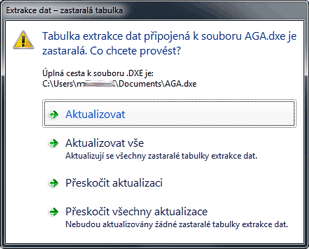
Automatic updates are controlled with the DXEVAL variable. Its default value of 12 means table updates on the PLOT and PUBLISH operations (command invokes). By changing the DXEVAL settings you can invoke table updates also on Open, Save, eTransmit - either with a prompt or fully automatically, silently (the value 192 means "no prompts"). The update prompt (e.g. on starting PLOT) looks like this (CZ version):
Please consider possible setting on Open/Save - the table updates may take a while on larger drawings.
ACAD
8.6.2012
14624×
this tip shared by ARKANCE experts applies to: AutoCAD ·

CADforum
Tips, tricks, utilities, help, how-tos and FAQ for AutoCAD, LT, Inventor, Revit, Map, Civil 3D, Fusion, Forma, 3ds Max and other Autodesk software (community support by ARKANCE). See About CADforum.
Copyright © 2026 | Advertise with us | Online privacy