![CAD Forum - tips, tricks, discussion and utilities for AutoCAD, Inventor, Revit and other Autodesk products [www.cadforum.cz]](../common/arkance_186.png "CAD Forum - ARKANCE Community - tips, tricks, discussion and utilities for AutoCAD, Inventor, Revit and other Autodesk products [www.cadforum.cz]")
CAD FORUM - TIPS & TRICKS | UTILITIES | DISCUSSION | BLOCKS | SUPPORT | HELP & ASSISTANCE

 What is the ARKANCE Community?
Over 1.127.000 registered users (EN+CZ).
AutoCAD tips, Inventor tips, Revit tips, Civil tips, Fusion tips.
The new Beam calculator, Spirograph generator and Regression curves in the Converters section.
New AutoCAD 2027 commands and sys.variables

 CAD tip # 7118:
Question
A
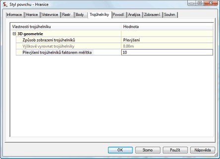
If you need to emphasize the shape of your terrain model - make it more "dramatic" for the documentation of your project, you can use the vertical exaggeration. All Z-axis values will be multiplied by a factor - similarly to e.g. Google Earth.
You can find the exaggeration settings in the surface style dialog. On the Triangles tab switch the "Triangle Display Mode" to Exaggerate Elevations and then enter the exaggertaion factor (e.g. 3x, 10x) in "Exaggerate Elevations By":
You can use the same approach for terrain analysis.
Civil2010Civil2009
18.12.2009
17141×
this tip shared by ARKANCE experts applies to: Civil 3D 2010 · Civil 3D 2009 ·

CADforum
Tips, tricks, utilities, help, how-tos and FAQ for AutoCAD, LT, Inventor, Revit, Map, Civil 3D, Fusion, Forma, 3ds Max and other Autodesk software (community support by ARKANCE). See About CADforum.
Copyright © 2026 | Advertise with us | Online privacy