![CAD Forum - tips, tricks, discussion and utilities for AutoCAD, Inventor, Revit and other Autodesk products [www.cadforum.cz]](../common/arkance_186.png "CAD Forum - tips, tricks, discussion and utilities for AutoCAD, Inventor, Revit and other Autodesk products [www.cadforum.cz]")
CAD FORUM - TIPS & TRICKS | UTILITIES | DISCUSSION | BLOCKS | SUPPORT | HELP & ASSISTANCE

Over 1.091.000 registered users (EN+CZ).
AutoCAD tips, Inventor tips, Revit tips.
Try the new precise Engineering calculator.
New AutoCAD 2026 commands and variables.
 CAD tip # 7965:
Question
A
With the LISP utility CADstudio SlopeTick you can easily create terrain slope lines (ticks) in AutoCAD:
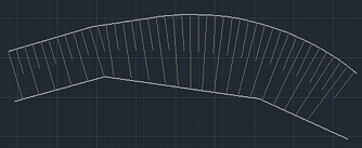
There is a similar function (automatic) in AutoCAD Civil 3D, or you can use the dynamic block Terrain slope (by zdrk).
You can download the SlopeTick free utility from Download
Since version 1.4 you can set the size of shorter lines with the LISP variable slopetickshort - e.g.: (setq slopetickshort 0.33)
ACADCivilADTMap
9.5.2011
76020×


CADforum
Tips, tricks, utilities, help, how-tos and FAQ for AutoCAD, LT, Inventor, Revit, Map, Civil 3D, Fusion, Forma, 3ds Max and other Autodesk software (community support by ARKANCE). See About CADforum.
Copyright © 2025 | Advertise with us | Online privacy