![CAD Forum - tips, tricks, discussion and utilities for AutoCAD, Inventor, Revit and other Autodesk products [www.cadforum.cz]](../common/arkance_186.png "CAD Forum - tips, tricks, discussion and utilities for AutoCAD, Inventor, Revit and other Autodesk products [www.cadforum.cz]")
CAD FORUM - TIPS & TRICKS | UTILITIES | DISCUSSION | BLOCKS | SUPPORT | HELP & ASSISTANCE

Over 1.096.000 registered users (EN+CZ).
AutoCAD tips, Inventor tips, Revit tips.
Try the new precise Engineering calculator and the updated Barcode generator.
New AutoCAD 2026 commands and variables.
 CAD tip # 7855:
Question
A
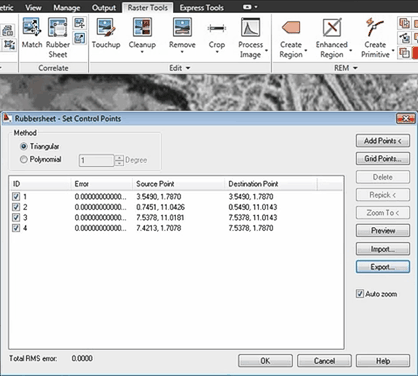
AutoCAD Raster Design offers the "Rubbersheet" function for multi-point transformations of raster images - e.g. aerial photos or scanned maps.
In the ribbon Correlate run the function "Rubber Sheet" and in the dialog "Control points" specify the pairs of alignment points (any number). You can select the triangular or polynomial transformation method.
COACAD2011
13.3.2011
16404×
applies to: Raster Design · AutoCAD 2011 ·


CADforum
Tips, tricks, utilities, help, how-tos and FAQ for AutoCAD, LT, Inventor, Revit, Map, Civil 3D, Fusion, Forma, 3ds Max and other Autodesk software (community support by ARKANCE). See About CADforum.
Copyright © 2025 | Advertise with us | Online privacy