![CAD Forum - tips, tricks, discussion and utilities for AutoCAD, Inventor, Revit and other Autodesk products [www.cadforum.cz]](../common/arkance_186.png "CAD Forum - ARKANCE Community - tips, tricks, discussion and utilities for AutoCAD, Inventor, Revit and other Autodesk products [www.cadforum.cz]")
CAD FORUM - TIPS & TRICKS | UTILITIES | DISCUSSION | BLOCKS | SUPPORT | HELP & ASSISTANCE

 What is the ARKANCE Community?
Over 1.123.000 registered users (EN+CZ).
AutoCAD tips, Inventor tips, Revit tips, Civil tips, Fusion tips.
The new Beam calculator, Spirograph generator and Regression curves in the Converters section.
New AutoCAD 2027 commands and sys.variables

 CAD tip # 7273:
Question
A
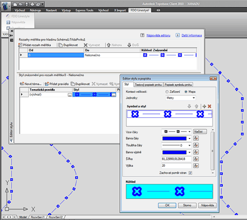
AutoCAD Map 3D, Autodesk Topobase and MapGuide support also special user-defined custom line symbols (linetypes). The definitions of the line styles have to be done directly in the XML format and so it is quite difficult to make your own line styles.
With the free utility CADstudio FDO LineStyle you can now generate such line styles much more easier, directly from AutoCAD drawing objects. This application converts (exports) objects of the type LWPOLYLINE, LINE, ARC, CIRCLE and TEXT directly to the corresponding XML definition.
You can find more information about FDO LineStyle (FDOLS) and the download link on www.cadstudio.cz/FDOLS.
Map2010Civil2010TB2010MapG
18.3.2010
21516×
this tip shared by ARKANCE experts applies to: AutoCAD Map 3D 2010 · Civil 3D 2010 · Topobase/MapServer 2010 · MapG ·

CADforum
Tips, tricks, utilities, help, how-tos and FAQ for AutoCAD, LT, Inventor, Revit, Map, Civil 3D, Fusion, Forma, 3ds Max and other Autodesk software (community support by ARKANCE). See About CADforum.
Copyright © 2026 | Advertise with us | Online privacy