![CAD Forum - tips, tricks, discussion and utilities for AutoCAD, Inventor, Revit and other Autodesk products [www.cadforum.cz]](../common/arkance_186.png "CAD Forum - tips, tricks, discussion and utilities for AutoCAD, Inventor, Revit and other Autodesk products [www.cadforum.cz]")
CAD FORUM - TIPS & TRICKS | UTILITIES | DISCUSSION | BLOCKS | SUPPORT | HELP & ASSISTANCE

Over 1.096.000 registered users (EN+CZ).
AutoCAD tips, Inventor tips, Revit tips.
Try the new precise Engineering calculator.
New AutoCAD 2026 commands and variables.
 CAD tip # 12847:
Question
A
When adding a raster map to your project in the BIM/GIS application Autodesk Infraworks, you may need to make a part of a map transparent, e.g. to underlay it and add another map layer.
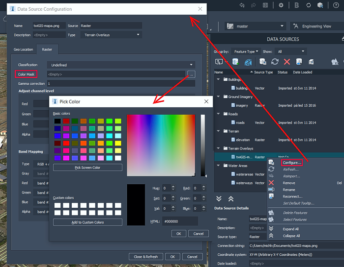
After you add a new data source of the type "Raster image", right-click on the added source in the "DATA SOURCES" palette (see the map twiGIS in Terrain overlays in the example below) and choose "Configure...".
In the "Data Source Configuration" dialog then proceed to the Raster tab and click on the button ".." in the field "Color Mask". Specify, choose or pick (in the map) the color, which should be transparent in the map. The color is used without any tolerance, so this is not suitable for raster images using a lossy compression, e.g. JPG.
IW
15.1.2021
16082×
applies to: Infraworks ·


CADforum
Tips, tricks, utilities, help, how-tos and FAQ for AutoCAD, LT, Inventor, Revit, Map, Civil 3D, Fusion, Forma, 3ds Max and other Autodesk software (community support by ARKANCE). See About CADforum.
Copyright © 2025 | Advertise with us | Online privacy