![CAD Forum - tips, tricks, discussion and utilities for AutoCAD, Inventor, Revit and other Autodesk products [www.cadforum.cz]](../common/arkance_186.png "CAD Forum - tips, tricks, discussion and utilities for AutoCAD, Inventor, Revit and other Autodesk products [www.cadforum.cz]")
CAD FORUM - TIPS & TRICKS | UTILITIES | DISCUSSION | BLOCKS | SUPPORT | HELP & ASSISTANCE

Over 1.092.000 registered users (EN+CZ).
AutoCAD tips, Inventor tips, Revit tips.
Try the new precise Engineering calculator.
New AutoCAD 2026 commands and variables.
 CAD tip # 5934:
Question
A
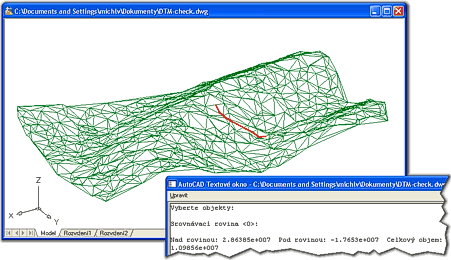
CADstudio DTM is a freeware application for 3D terrain modelling in plain AutoCAD. You can use it for visualizations and simple terrain calculations and analysis.
The application is based on a TIN generator by D.Piazza and contains enhancements and functions from the CADstudio's application GEOsurf.
DTM allows to generate triangular terrain model (3DFaces) from any 3D points (objects) or contours in your DWG file. With this model you can then perform other operations - e.g. calculate volumes (above/below a reference plane), estimate point elevations on the model, generate flowlines. You can also use a generator of random 3D terrains.
(For advanced terrain modelling functionality we recommend to upgrade to AutoCAD Civil 3D.)
More information on www.cadstudio.cz/dtm
You can download the "DTM" application from  Download (see the Readme).
ACADMap
11.1.2008
31883×
FAQ
applies to: AutoCAD · AutoCAD Map 3D ·

CADforum
Tips, tricks, utilities, help, how-tos and FAQ for AutoCAD, LT, Inventor, Revit, Map, Civil 3D, Fusion, Forma, 3ds Max and other Autodesk software (community support by ARKANCE). See About CADforum.
Copyright © 2025 | Advertise with us | Online privacy