![CAD Forum - tips, tricks, discussion and utilities for AutoCAD, Inventor, Revit and other Autodesk products [www.cadforum.cz]](../common/arkance_186.png "CAD Forum - ARKANCE Community - tips, tricks, discussion and utilities for AutoCAD, Inventor, Revit and other Autodesk products [www.cadforum.cz]")
CAD FORUM - TIPS & TRICKS | UTILITIES | DISCUSSION | BLOCKS | SUPPORT | HELP & ASSISTANCE

 What is the ARKANCE Community?
Over 1.127.000 registered users (EN+CZ).
AutoCAD tips, Inventor tips, Revit tips, Civil tips, Fusion tips.
The new Beam calculator, Spirograph generator and Regression curves in the Converters section.
New AutoCAD 2027 commands and sys.variables

 CAD tip # 12163:
Question
A
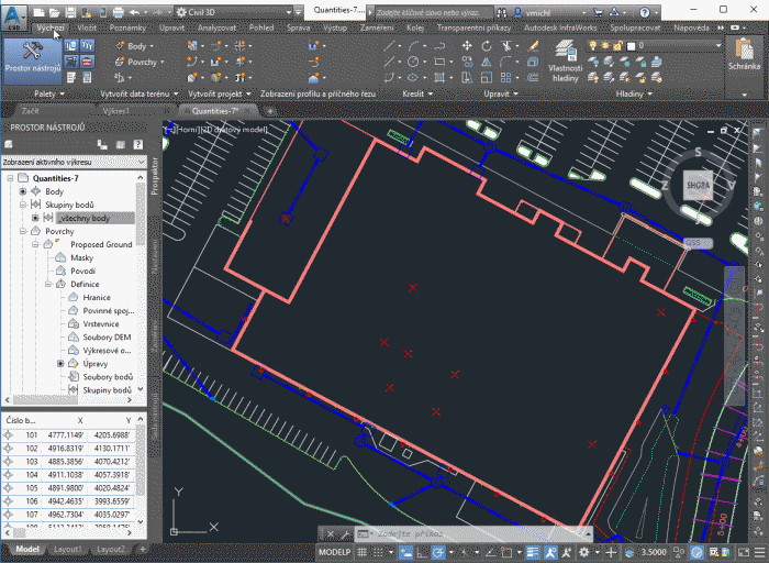
In Civil 3D you can use a counple of useful transparent commands to specify locations (XYZ coordinates) through COGO point numbers or names.
If you have a sequentially numbered survey points in your project and you need to connect them with a polyline or feature line, you can specify the range of points to connect with a numeric range, e.g. connect points 101-137.
For this feature you can use the transparent commands (see the ribbon) 'PN (point number) and 'PA (point name) and 'PO (point object). The points can be referenced individually or (in the case of point numbers) also as a range of numbers (from-to).
See the connecting polyline through the points 101 to 109:
Civil
8.3.2019
11651×
this tip shared by ARKANCE experts applies to: Civil 3D ·

CADforum
Tips, tricks, utilities, help, how-tos and FAQ for AutoCAD, LT, Inventor, Revit, Map, Civil 3D, Fusion, Forma, 3ds Max and other Autodesk software (community support by ARKANCE). See About CADforum.
Copyright © 2026 | Advertise with us | Online privacy