![CAD Forum - tips, tricks, discussion and utilities for AutoCAD, Inventor, Revit and other Autodesk products [www.cadforum.cz]](../common/arkance_186.png "CAD Forum - tips, tricks, discussion and utilities for AutoCAD, Inventor, Revit and other Autodesk products [www.cadforum.cz]")

 CAD tip # 9743:
Question
But you cannot use a plain copy/paste as AutoCAD expects XY coordinates delimited by comma and a dot "." as the decimal separator (Excel uses comma in some European localizations). So you need to first concatenate the Excel columns containing the X-coordinate and Y-coordinate to a single value. Use string concatenation and the function "SUBSTITUTE" (WECHSELN in German, SUBSTITUE in French, SOSTITUISCI in Italian, SUSTITUIR in Spanish, SUBSTITUEREN in Dutch, PODSTAW in Polish, ПОДСТАВИТЬ in Russian) if needed to replace commas with dots. So e.g. to combine the A and B columns on the second row, the function will look so:
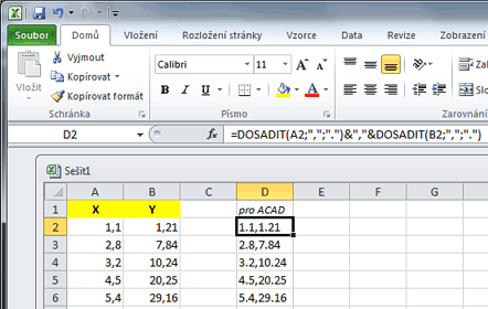
=SUBSTITUTE(A2;",";".")&","&SUBSTITUTE(B2;",";".")
or just:
=A2&","&B2
If the decimal comma replacement is not needed and if the list separator defined in your Windows localization is a comma (not semicolon), you can also use the CSV export from Excel to get a proper list of XY coordinates for AutoCAD.
Then just select the newly created column in Excel from the first to the last used row, press Ctrl+C and in AutoCAD paste this data using mouse right-click on the prompt for entering vertex coordinate in the started command PLINE.
You can use this procedure to draw any math curve/function (parabola, sinusoid...) or otherwise acquired XY values, both in AutoCAD and in AutoCAD LT. In the full AutoCAD version you can also draw functions with 2DPLOT or more conveniently by transferring Excel data with Xls2Curve (see).

