![CAD Forum - tips, tricks, discussion and utilities for AutoCAD, Inventor, Revit and other Autodesk products [www.cadforum.cz]](../common/arkance_186.png "CAD Forum - tips, tricks, discussion and utilities for AutoCAD, Inventor, Revit and other Autodesk products [www.cadforum.cz]")

 CAD tip # 9512:
Question
In these cases, the freeware application MeshLab will help you. You can download it from meshlab.sourceforge.net [URL verified 10/2013]
Be careful when installing this app in Windows 8 - you need to just unpack, not install the MeshLab installation file (e.g. with 7-Zip)
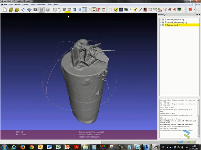
A point cloud read from any point file format into Autodesk ReCap need to be written (saved) to PTS file. Then rename the .pts file on your disk to the extension .ASC. ASC files can be then directly imported into MeshLab. It is advisable to simplify large models by reducing the number of points (Filters > Sampling > Poisson-disk Sampling). First generate normals on the loaded model:
Render > Show vertex normals
Save the file (Export Mesh, .ply) with the option Normals and re-open it
Filters > Point Set > Compute normals for point sets
Consequently, it is now possible to generate a 3D grid (mesh) model:
Filters > Point Set > Surface Reconstruction: Poisson
Another option (in newer versions of Meshlab) is to generate mesh directly from the points using the command Filters > Remeshing, Simplification and Reconstruction > Surface Reconstruction: Ball Pivoting (radius cca 0.1).
Remember to use the top command bar to switch to the 3D mesh model.
The resulting 3D model can be then saved to a DXF or OBJ format that can be loaded into any standard 3D CAD application.
The detailed procedure can be found in the video on the CAD Studio's YouTube channel:
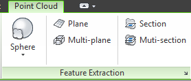
In some cases, you can also use the free application "Point Cloud Feature Extraction" available on Autodesk Exchange Apps. It allows to create AutoCAD geometry - polylines, arcs, splines, cylinders, spheres, anuloids - from point clouds.