CAD Forum - tips, tricks, discussion and utilities for AutoCAD, Inventor, Revit and other Autodesk products [www.cadforum.cz]
CZ | EN | DE
Login or
registration
  Visitors: 7116
Plex.Earth connects AutoCAD and Google Earth

CAD tip CAD tip # 6048:

   
Question CAD 
 %  platform  category 
Q - question

Adding your home city to the list for geographic location settings.

A - answer Many Autodesk applications can use the information about the geographical location of your project - either for the calculation of the position of the Sun as a light source for rendering, or for energy calculations of your building (gbXML).

When specifying the location of your project you can use a list of names and geographic coordinates of the most important world cities. If you want to add your own home city or village to this list, you can do so - extend the list of "important" places.

Autodesk applications use the list of cities stored in the file SITENAME.TXT. This file can be found in AutoCAD (and applications based on AutoCAD), in Revit and in the visualization programs Autodesk VIZ and 3ds Max.

You can find the SiteName.txt file in folders like:

C:\Users\username\AppData\Roaming\Autodesk\AutoCAD 2009\R17.2\enu\Support  
C:\Documents and Settings\username\Local Settings\Application Data\Autodesk\AutoCAD 2008\R17.1\enu\Support  
C:\Documents and Settings\username\Local Settings\Application Data\Autodesk\ADT 2005\enu\VIZRender\PLugCFG  
\3dsmax7\plugcfg  
C:\Program Files\Revit Architecture 2008\Program
or similar. As an exception, the rendering function in older versions of Revit (Accurender) uses a similar file in:
C:\Program Files\Revit Architecture 2008\Program\Ar3Redist\UnicodeENU\ar_city.uni

Open your SiteName.txt file in the Notepad.exe editor and add a new line to the list of cities (example):

+48.9754 +14.4761 +Ceske Budejovice, Czech Republic
where the first two values are the latitude/longitude values for the specific site in decimal notation. These values can be easily found using a GPS unit or from online mapping web sites like maps.google.com.

After you save the changed file Sitename.txt, do not forget to restart your CAD application.

Geographic location - AutoCAD (CZ) Geographic location - Revit (CZ)

ACADADTCivilRevitVIZMax
100% *  CAD 
27.3.2008    11095×  
applies to: AutoCAD · AutoCAD Architecture · Civil 3D · Revit · VIZ · 3ds Max ·

See also:
Tip 13971:What do geolocation codes like 8FWPXFCF+82 or 33UVQ61402434 mean?
Tip 13296:How to correctly load a KML/KMZ file into Civil or Map 3D?
Tip 10848:GeoCode with what3words location codes.
Tip 9593:Reverse geocoding - find street address of a point on map.
Tip 9202:The geolocation LiveMap in AutoCAD 2014 is off scale.
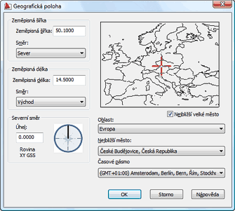
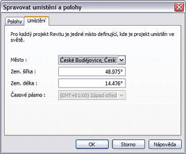

Back   All CAD Tips


Have we helped you? If you want to support the CAD Forum web service, consider buying one of our CAD applications, or our custom software development offerings, or donating via PayPal (see above). You may also add a link to your web - like this "fan" link: CAD Forum - tips, utilities, blocks for Autodesk products
CAD:    OS:    Categ: 
Text:  FAQ glossary   


Featuring:
Increase your productivity with our set of add-on functions for AutoCAD Civil 3D
CADstudio Civil Tools More info


Please use these tips at your own risk.
Arkance Systems is not responsible for possible problems that may occur as a result of using any of these tips.
TOPlist